IARN — A La Nina weather pattern officially formed as of September 10th, according to the US Department of Agriculture.
In a previous interview with the Iowa Agribusiness Radio Network, Iowa state climatologist Dr. Justin Glisan indicated we were in the transition period to the La Nina pattern. He describes what that means across the country.
“We have all heard of El Nino, which is the warm phase,” Glisan said. “La Nina is the cold phase. Typically, when we do transition into La Nina conditions, what that means for late fall is we really don’t have a clear picture, but getting into winter the upper Midwest does typically experience colder than average temperatures. The Ohio Valley has a slightly elevated chance of wetter conditions. Iowa just happens to be right in the middle.
Glisan provides a look at previous La Nina experiences.
“If we’re looking at analog years for La Nina, we don’t get a clear signal yet, but on the temperature side we may expect some colder air outbreaks like we saw in 2018, but also colder conditions across the board for winter time,” Glisan said. “We still have a few iterations of those outlooks to go through.”
USDA meteorologist Brad Rippey says another impact of La Nina is a very active Atlantic hurricane season.
“We are at a record setting pace in terms of name storms,” Rippey said. “We see no sign of that abating. There is a literal storm train of waves coming off the African coast. Not all of them developed into named tropical storms or hurricanes, but enough of them continue to do so that we remain on this record setting pace.”
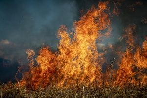
Rippey also noted that the conditions that led to the La Nina pattern’s formation have already influenced this year’s wildfire season. California, for example, is having its worst wildfire season on record.
Story courtesy of the Iowa Agribusiness Radio Network.
Photo by NOAA