

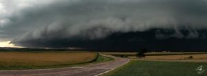
Northwest Iowa — Multiple rounds of severe weather moved across portions of southeastern SD, northwestern IA, and southwestern MN during the afternoon/evening hours on Saturday, Aug. 28, 2021.
Extremely large hail, damaging winds, tornadoes, and flooding were reported. The combination of torrential rainfall and numerous rounds of storms triggered both flash flooding and river flooding for portions of the area, despite the drought conditions present at the time of the event.
Severe thunderstorm warnings started going into effect in the four county area around 4:00 pm on Saturday and continued through 9 pm.
At 4:22 pm, an EF-1 tornado was reported west of Lennox, South Dakota and lifted east of the town. No injuries or fatalities were reported.
According to the National Weather Service, from 7:30 pm to 8 pm, spotters reported quarter to tennis ball sized hail around Larchwood and Lester.
At 10:42 pm, 4 miles west-northwest of Spencer, wind gusts of 75 miles per hour were reported at the Spencer Airport.
Rock Rapids received 2.58 inches of rain, and Sheldon received 1.23 inches of rain.