
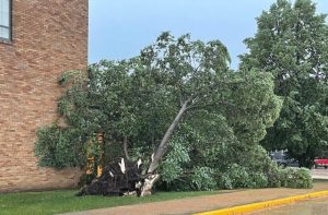
Northwest Iowa — The powerful storms that thundered across Iowa Tuesday night MIGHT be classified as another derecho, what would be the third such storm in three years. Meteorologist Roger Vachalek, at the National Weather Service, says a derecho is a long-running, straight-line wind storm associated with fast-moving severe thunderstorms.
Iowa experienced very damaging derechos in August of 2020 and in December of 2021. Last night’s severe storms dropped inch-diameter hail in Worth County and up to four inches of rain in some areas, which prompted flash flooding, along with very strong winds.
Tornado sirens sounded in a few Iowa communities Tuesday, but as of yet, there have been NO twisters confirmed.
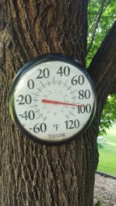
On the plus side, slightly cooler weather is coming behind the storm. After high temperatures mostly in the 90s the past few days, forecasters say highs through Saturday may only be in the 80s, before the heat returns Sunday and into Monday.