

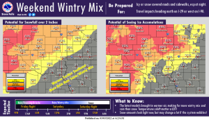
Northwest Iowa — Confidence is increasing that a strong storm system will affect regional travel Friday night through Saturday night.
Although amounts look fairly light at this point, any subtle changes in temperatures aloft as the system wobbles closer could shift higher snowfall amounts further east or west. Some sites will see wintry mix developing late Friday night through Saturday as colder air moves in, especially in South Dakota. Further east, warmer air lingering longer means more rain than wintry precipitation. Parts of Iowa may even see thunderstorms and potential for severe weather Saturday. Make sure to keep checking for forecast updates as the weekend approaches!