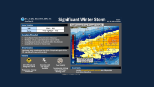
Northwest Iowa — The Winter Storm has arrived! Locations without snow as of early morning will see conditions start to degrade later this morning and this afternoon, with many areas expected to see snowfall rates to around an inch an hour at times.
Travel impacts will be considerable due to accumulating snowfall and poor visibility, so consider delaying unnecessary travel. A large area will receive from 6 to 10 inches of snowfall, with a few locally heavier amounts. Snow will taper off tonight, and leave a more sunny and slowly warming weekend.
Osceola-Dickinson-O`Brien-Clay-Cherokee-Buena Vista-Cottonwood-
Jackson-
221 PM CST Fri Dec 10 2021

...WINTER STORM WARNING NOW IN EFFECT UNTIL 3 AM CST SATURDAY...

* WHAT...Heavy snow. Additional snow accumulations of 5 to 10
  inches, with the highest amounts in portions of southwest
  Minnesota. Winds gusting as high as 35 mph this afternoon.

* WHERE...Portions of northwest Iowa and southwest Minnesota.

* WHEN...Until 3 AM CST Saturday.

* IMPACTS...Travel could be very difficult. Patchy blowing snow
  could significantly reduce visibility. The hazardous
  conditions could impact the evening commute.

PRECAUTIONARY/PREPAREDNESS ACTIONS...

If you must travel, keep an extra flashlight, food, and water in
your vehicle in case of an emergency.

The latest road conditions for the state you are calling from can
be obtained by calling 5 1 1.