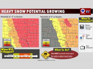
Northwest Iowa — Trends continue to show an increasing potential for moderate to heavy snowfall over many areas, especially near and east of Interstate 29 from late Thursday night through Friday evening.
A winter storm watch has been posted from east central SD into southwest MN and much of northwest IA.
...WINTER STORM WATCH IN EFFECT FROM FRIDAY MORNING THROUGH
FRIDAY EVENING...

* WHAT...Heavy snow possible. Total snow accumulations of 5 to 7
  inches possible.

* WHERE...Portions of northwest and west central Iowa.

* WHEN...From Friday morning through Friday evening.

* IMPACTS...Travel could be very difficult. The hazardous
  conditions could impact the morning or evening commute.

* ADDITIONAL DETAILS...Northerly winds gusting 25 to 35 mph on
  Friday evening may cause patchy blowing and drifting snow.

PRECAUTIONARY/PREPAREDNESS ACTIONS...

Monitor the latest forecasts for updates on this situation.
Today will be another mild day with most temperatures 10 to 20 degrees above normal. After a cold front works through today, a weak system tonight may bring a spotty light wintry mix to southwest Minnesota, but a greater impact will be to take off a few more degrees to temperatures on Thursday. The biggest feature of the forecast remains a clipper system which will brand the area with accumulating snowfall on Friday into Friday evening. Some areas of heavier snowfall are possible, and a winter storm watch has been posted from parts of northeast and east central SD through southwest MN into northwest IA. Pay attention to the forecast as we close in on the latter part of the work week, as uncertainties remain as to locations for the heaviest snow potential.