IARN — Iowa saw another week of drought improvement, according to the U.S. Drought Monitor released Thursday morning.
Iowa State Climatologist Dr. Justin Glisan says recent rain showers have helped improve dry conditions in the central and eastern parts of the state.
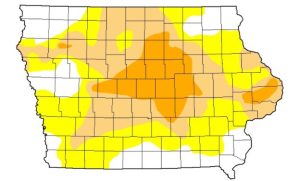
“Good improvement across eastern Iowa,” said Glisan. “We actually saw a pretty potent low-pressure system move through the Upper Midwest and a cold front came through Iowa, so we did get some thunderstorms and some widespread rainfalls of a half an inch and an inch plus, especially from central into eastern Iowa. That’s where we saw a one category improvement in the drought categories.”
Glisan explains that there wasn’t much change, though, in western Iowa on a week-to-week basis.
“If we look at western Iowa, basically status quo because the rainfalls we did see were just enough to keep us at climatology,” said Glisan. “There was a small pocket of D0 introduced in southwestern Iowa in Harrison, Shelby and Pottawattamie counties. This is more reflective of shorter-term rainfall deficits. D0 is not drought, but it’s abnormal dryness.”
For farmers, Glisan says conditions have essentially been perfect for the 2021 harvest.
“We’ve had a pretty phenomenal harvest window here with drier than normal conditions,” said Glisan. “We’ve been getting some timely rainfalls, but some above average temperatures and windy days have really helped get the moisture out and get the combines back in the fields after those rain events.”
The latest U.S. Drought Monitor for Iowa can be found here.
Story courtesy of the Iowa Agribusiness Radio Network.
Pictured: U.S. Drought Monitor map for Iowa on 10-14-2021.


