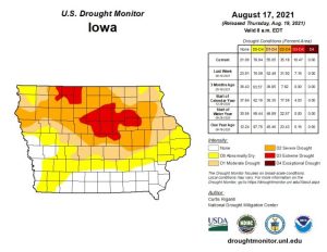
IARN — The U.S. Drought Monitor on Thursday once again showed drought expansion across Iowa.
Iowa State Climatologist Dr. Justin Glisan explains the lack of rain in August has led to drought conditions covering the northern two-thirds of the state.
“The last seven days we’ve had no measurable rainfall across much of the state,” said Glisan. “Combined with those high temperatures, we did see degradation in parts of southeastern Iowa, but also expansion of those D3 regions in north central and northwestern Iowa. We’re getting into the warmest part of the year. Luckily, we’ve had higher humidity and higher dew points, so even with those warmer temperatures we do see some mitigation of moisture stress.”
Glisan says crops are looking surprisingly good across the state amid the dry conditions.
“Luckily, we’ve had timely rains,” said Glisan. “We got planted pretty early and we had rainfall. Pollination and tasseling we’ve had rainfall and cooler temperatures. So we’ve had those million dollar rains right when we need them. Hopefully over the next few days we get another million dollar rain to help finish off the crop as we get into harvest.”
Glisan looks ahead at some of the longer-range forecasts as growers prepare for harvest season.
“September, October and November wise we are seeing elevated chances of warmer temperatures,” said Glisan. “Most likely as we move from the warm season into fall, those are coupled with near normal or drier conditions. Of course, that would be excellent for harvest, but we do need to replenish those subsoil profiles. It’s going to take a lot of rainfall, a lot of fall precipitation, and winter snowpack to really get moisture into the ground for next growing season.”
The latest U.S. Drought Monitor can be viewed here.


