Northwest Iowa — Dry ground, unseasonable temperatures and high winds have combined to cause an increased fire danger, resulting in Red Flag Warnings several times in the past weeks.
One of the tools that emergency managers and others use to keep an eye on conditions–and possible fires–comes from NASA satellites.
They provide updated information about every three hours through their remote sensing equipment.
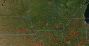
NASA warns, however, that there can be anomalies in the satellite photos caused by industry, agriculture, a localized burn, or weather.
NASA FIRMS uses satellite observations from the MODIS and VIIRS instruments to detect active fires and thermal anomalies and deliver this information in near real-time to decision makers through email alerts, analysis ready data, online maps and web services.
According to NASA, the FIRMS system was originally developed by the University of Maryland, with funds from NASA’s Applied Sciences Program and the United Nations Food and Agriculture Organization (UN FAO). It was transitioned to NASA LANCE in 2012.
For more information, visit firms.modaps.eosdis.nasa.gov.
Photo courtesy of NASA. Each red dot on the map is an indication of a fire hazard area over the past two weeks.