
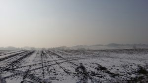
Statewide, Iowa — Wind chill factors are below zero across much of Iowa Friday morning, while forecasters say high temperatures in multiple cities will likely set records this afternoon for being so cold.
Meteorologist Mike Fowle, at the National Weather Service, says the high temp in Des Moines won’t even be half of what it should be for this date.
Elsewhere, Ottumwa may only see 23 degrees for a high today. The record low is 24 and the normal high is 48. In addition to the cold air temperatures, Fowle says those wind gusts will be sharp.
Parts of Iowa got more than four inches of snow earlier this week, but there’s no more significant accumulation in the immediate forecast.
The extended forecast for much of Iowa next week shows little-to-no snow and highs in the 30s and 40s through Thanksgiving.
As for northwest Iowa, the current forecast shows we are looking at having highs in the mid-to-upper 30’s going up to Thanksgiving. The forecast also currently shows after Saturday, November 19th, precipitation is not currently forecast through Thanksgiving day.