


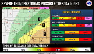
Northwest Iowa — Severe storms are likely, mainly in northwest Iowa Tuesday night. While all severe hazards will be possible, there remains some uncertainty in where storms will initially develop and how far north storms will track.
Continue to monitor the forecast for the latest updates!

Periods of light snow are possible Tuesday night through Thursday. There is uncertainty regarding if and where snow will fall as dry air may prevent snow from occurring entirely. Continue to monitor the forecast for the latest information.

Strong winds begin out of the southeast on Tuesday before turning to out of the northwest Tuesday night. Winds will stay out of the west/northwest into Thursday. Gusts as high as 30-50+ mph will be possible before winding down on Friday. Make sure to secure any loose items and drive to conditions if you must travel!

A strong storm system will affect the area on Tuesday, bringing the chance for severe weather. Much colder air will be ushered in, in the wake of the system, resulting in below average high temperatures. Strong winds are also likely with the cold temperatures, possibly gusting into the 40-50+ mph range. Some snow is also possible but details are still uncertain at this time. Winds calm down for the end for the week as the system pulls away.


