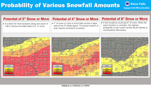
Northwest Iowa — The first significant winter storm of the season is on its way for late Thursday night through Friday night. Snowfall amounts are still uncertain, but a Winter Storm Watch has been issued for much of the area Friday morning through Friday evening for the possibility of heavy snow. Those with travel or outdoor interests should monitor their favorite reliable weather source. After the snow ends, the weekend forecast has plenty of sunshine and warmer temperatures.
Although specific snowfall amounts are not certain yet, here is a look at the probability of 2 inches or more, 4 inches or more, and 8 inches or more snowfall from the winter storm late Thursday night through Friday night. As of Wednesday evening, much of the area is forecast to receive 2 to 4 inches of snow. However, it is also likely that a heavier band will set up somewhere near or southeast of Menno, South Dakota to Marshall, Minnesota, possibly producing 8 inches or more.


