
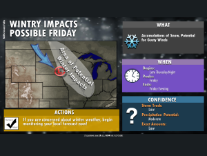
Northwest Iowa — Trends in forecast guidance are starting to suggest an increasing chance for impactful winter weather with a clipper system in parts of the region, including areas near/east of Interstate 29.
With considerable uncertainty to the track and thus potential amounts (the system early Tuesday morning is well out in the Pacific Ocean), you should be sure to keep up with the latest forecast over the next few days.
Much warmer temperatures with highs in the 40s (a few lower 50s in the Missouri River valley) are expected today as westerly winds spread in behind a warm front. The quiet and mild weather will linger through Thursday, however temps will begin to slip a bit behind a Wednesday cold front. The big change will come as a clipper system dives into the region on Friday, which now looks to impact much of the area with a threat for accumulating snowfall, especially from near I-29 eastward.