


Northwest Iowa — For the second time in 36 hours, a round of severe thunderstorm warnings were issued for the broadcast area.
Just past midnight, at 12:10 a.m. Wednesday the National Weather Service issued a severe thunderstorm watch that was set to expire at 8:00 a.m. Wednesday morning.
Thunderstorms came across southeast South Dakota and northeast Nebraska, triggering Severe Thunderstorm Warnings. Starting at 3:58 a.m. the National Weather Service in Sioux Falls issued the first of many warnings as the storms progressed through the broadcast area. This Severe Thunderstorm Warning had a primary hazard of 70 mph wind gusts.
Less than 30 minutes later, at 4:21 a.m., another warning was issued — this one for all of Lyon County, northwestern Osceola County, and the majority of Sioux County. This warning was also the result of 70 mph wind gusts. The system was moving into the area at 60 mph. This Severe Thunderstorm Warning was termed a “dangerous situation”, and noted that the storms were producing widespread wind damage across eastern South Dakota.
At 4:59 a.m., the National Weather Service in Sioux Falls issued another Severe Thunderstorm Warning until 5:45 a.m. This warning was for much of Lyon County, the majority of Osceola County, the eastern portion of Sioux County, and the majority of O’Brien County. This warning did have slower wind gusts indicated by radar at 60 mph. The National Weather Service reported that the storms were producing widespread damage across far northwest Iowa.
There were numerous reports given to KIWA, as well as the National Weather Service. According to the National Weather Service, at 4:52 a.m., there were reports of 53 mph. wind gusts east-southeast of Hawarden. There were also reports of wind damage in Hull, and of a tree branch and power line down reported by law enforcement at 4:58 a.m. according to the weather service.
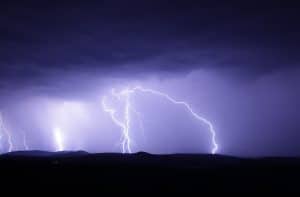
A listener reported strong winds, heavy downpouring, and lots of lightning at Carnes at 5:40 a.m. Another listener reported 2.01 inches of rain in Matlock. A listener reported 3½ inches of rain in northeast Sheldon. It was reported that Rock Rapids had 1.33 inches and 0.88 inches fell in George. Sister Community First Broadcasting Station KSOU in Sioux Center reported one inch of rainfall.
At the KIWA studios in downtown Sheldon, we had a total of 1 3/4 inches fall during the course of the early morning storms.
There were also some reports of power outages.