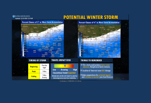
Northwest Iowa — The potential for the first significant snow of the season is growing, with accumulating snow likely for much of the area late Thursday night into Friday.
Exact snowfall amounts remain uncertain. Continue to monitor your local forecast for updates.

Sioux-O`Brien-Clay-Plymouth-Cherokee-Buena Vista-Woodbury-Dixon-
Dakota-Union-
331 AM CST Wed Dec 8 2021

...WINTER STORM WATCH IN EFFECT FROM FRIDAY MORNING THROUGH
FRIDAY EVENING...

* WHAT...Heavy snow possible. Total snow accumulations of 4 to 6
  inches possible.

* WHERE...Portions of southeast South Dakota, northeast Nebraska
  and northwest and west central Iowa.

* WHEN...From Friday morning through Friday evening.

* IMPACTS...Travel could be very difficult. Patchy blowing snow
  could significantly reduce visibility. The hazardous
  conditions could impact the morning or evening commute.


PRECAUTIONARY/PREPAREDNESS ACTIONS...

Monitor the latest forecasts for updates on this situation.


